The WWF is run at a local level by the following offices...
- WWF Global
- Adria
- Argentina
- Armenia
- AsiaPacific
- Australia
- Austria
- Azerbaijan
- Belgium
- Bhutan
- Bolivia
- Borneo
- Brazil
- Bulgaria
- Cambodia
- Cameroon
- Canada
- Caucasus
- Central African Republic
- Central America
- Chile
- China
- Colombia
- Croatia
- Democratic Republic of the Congo
- Denmark
- Ecuador
- European Policy Office
- Finland
ECOSEO: Protecting the Amazon Rainforest in the Guiana Shield
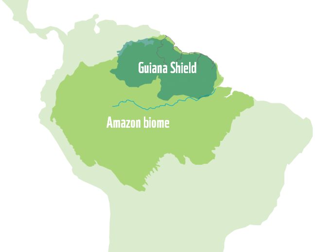
The immense Guiana Shield is located in northern South America, between the Amazon and Orinoco rivers. With an area of 270 million hectares, it encompasses approximately one third of Amazonia. The 1.7 billion-year-old geological formation is covered by a vast and diverse tropical forest. Ranging from lowlands and mid-altitude terrain to the heights of tepuis, geological formations perched above the alluvial plain that are typical of the region, the Guiana Shield is home to a very large variety of habitats, some of which are unique in the world. Still relatively untouched by industrial and extractivist development, which has caused significant destruction elsewhere in Amazonia, the region constitutes one of the rare expanses of well-preserved tropical forest left in the world. Still, it is under threat from gold mining and deforestation and its unique and exceptional biodiversity must be protected.
Forests and watercourses are under increasing pressure from human activities, including gold mining
Despite having one of the highest rates of forest cover in the world – an average of 86% – and relatively low deforestation – less than 1% between 2000 and 2015 – compared to other regions of Amazonia, the ecosystems of the Guiana Shield are facing increasing pressure from human activities, starting with gold mining.
Whether legal or illegal, gold mining is one of the main causes of deforestation in the region. Between the early 1990s and 2018, roughly 215,000 ha of forests and creek and riverbeds were destroyed, in particular over the last decade, during which the affected area tripled. That increase nevertheless progressed relatively differently depending on the territory. The increase observed in 2008-2018 (+ 145,000 ha) was particularly worrisome in the western part of the Guiana Shield, with 61% occurring in Guyana, 32% in Suriname, 5% in French Guiana and 2% in Amapá. Impact levels can be explained by differences in the geological context, but above all in socioeconomic and regulatory conditions. For example, while mercury has been prohibited in French Guiana since 2006, that powerful neurotoxin is still very frequently used in Suriname and Guyana. A project aiming to ban the use of mercury in gold mining, in which WWF is a partner, is currently underway in those two countries. Mercury pollutes watercourses, accumulates in food chains and contaminates indigenous populations, whose diet relies heavily on fish caught locally.
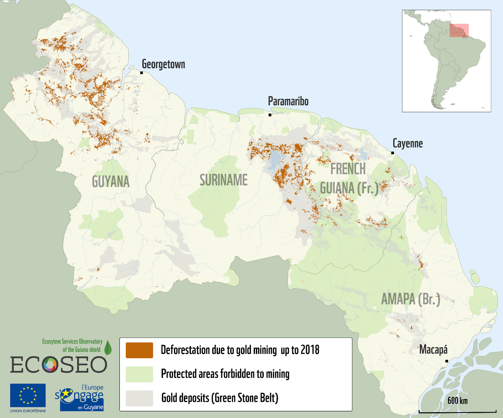
Map of the deforestation due to gold mining on the Guiana Shield up to 2018
Spatial planning in these territories, and in particular the expansion of agricultural and urban areas, also contributes to fragmenting and degrading the forest. Roughly 300,000 ha were converted for agriculture and 85,000 ha were artificialized between 2000 and 2015 at the scale of the four territories studied (Guyana, Suriname, French Guiana and Amapá). These phenomena can be explained by significant population growth in the Guianas and by the very marked increase in the population’s needs for housing, infrastructure, energy and food resources. While ensuring that these vital needs are met, it is essential to adhere to a fair and sustainable development trajectory in order to preserve the long-term balance of the region’s ecosystems.
WWF’s Actions
In 1999, WWF created a regional office in the Guianas covering Guyana and Suriname, implementing complex multi-donor conservation programs. WWF uses five means of action to achieve its aim of protecting the forests of the Guiana Shield over the long term.
First, together with WWF’s offices in Suriname, Guyana and Brazil, we support a regional cooperation network, the only pertinent scale for action to fight against the environmental pressures whose causes reach beyond administrative and political borders. As part of efforts to protect the Guiana Shield’s forest ecosystems, we have set up a unique and ambitious initiative to assess the region’s natural resources and the benefits the local population derives from them through the project for an Observatory of Ecosystem Services, ECOSEO, with our partners at the government agencies responsible for forestry and the environment in Guyana, Suriname, French Guiana and the Brazilian state of Amapá.
We have thus been able to create a unique set of land use maps at the scale of the four territories, which for the first time ever provides us with a vision of the changes that took place over 15 years, in particular of the deforested areas and the causes behind them. In continuity with earlier initiatives, this work has also made it possible to update mapping of the deforestation due to mining activities using satellite observation, which today allows us to go back almost 20 years (2001-2018). Thus we are the only organization to have produced this valuable indicator illustrating the progression of the phenomenon at a regional scale.
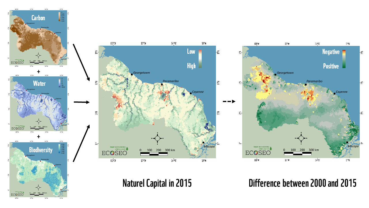
Simplified concept of the Natural Capital assessment in 2000 and 2015 on the Guiana Shield
Those ecosystem services are particularly important along the Maroni river, whose drainage basin is shared between Suriname and French Guiana. The region is above all a living area, home to a large population including indigenous Amerindian and Maroon (descendants of runaway slaves) communities, whose ways of life are closely tied to their natural surroundings. Creeks and rivers enable transport by canoe, the forest supplies building materials, food and medicine, and freshwater fish constitute the basis of their diet. Our work made it possible to carry out an initial assessment of these services at the scale of the Maroni river basin, using scientific methods and field data. Our results have highlighted the importance of these services for the local population while at the same time emphasizing the pressures that threaten them, starting with the impacts of gold mining.

Examples of ecosystem services on the Guiana shield
Finally, through its work, WWF seeks to showcase the exceptional natural and cultural heritage of the Guiana Shield beyond the region’s borders, in order to draw attention to the need to preserve it while enabling balanced economic and social development beneficial to local populations. It was to that end that WWF organized an event devoted to the Natural Capital of the Guiana Shield during the IUCN World Conservation Congress in Marseille, France in 2021, at which the results of the ECOSEO project were presented. Representatives of the Amerindian communities of the Upper Maroni river, from French Guiana and Suriname, were invited to attend to alert the public to the difficulties they are facing in their territory, linked in particular to the degradation of their environment.
Above all, our work, carried out in collaboration with our partners, has made it possible to test, for the first time at such a large scale, a method to assess natural capital, Ecosystem Natural Capital Accounting or ENCA, which is able to qualify and quantify changes taking place in the three major ecosystem compartments: carbon, water and biodiversity. Although it is still partially experimental, this method, recognized by the Convention on Biological Diversity (CBD), confirmed for the Guiana Shield the global importance of its stocks of carbon and freshwater as well as of its vast biodiversity, but also their marked degradation over 15 years, mainly in areas subjected to the pressure of gold mining. This work shows that, beyond their impact on deforestation, which is low when compared to the vastness of these territories, extractive activities affect all ecosystem compartments and the services they deliver to populations.
DOWNLOADS
 |
Summary - ECOSEO project booklet Main steps and outcomes of the ECOSEO project, Ecosystem services observatory of the Guiana Shield |
|
Report - Mapping land use land cover change in the Guiana Shield from 2000 to 2015 Land use and land cover changes maps in Guyana, Suriname, French Guiana and Amapá state in Brazil, between 2000 and 2015 |
|
Maps of the impact of gold mining in Guyana, Suriname, French Guiana and Amapá state in Brazil from 2001 to 2018 |
|
Report - Ecosystem natural capital accounting in the Guiana Shield in 2000 and 2015 Natural capital assessment and changes in 2000 and 2015 on the Guiana Shield
|
|
Report - Mapping and assessment of ecosystem services in French Guiana and Suriname Capacity of the natural habitats to provide ecosystem services in French Guiana and Suriname
|
|
Report - Ecosystem services in the Maroni basin Overview of the ecosystem services of the transboundary Maroni river basin and their uses by local communities
|